
Join Our Mailing List
Sign up to receive updates on our latest news and events. Your email will never be shared or sold and you can opt out at any time.
No thanks
Sign up to receive updates on our latest news and events. Your email will never be shared or sold and you can opt out at any time.
No thanksApproximately 5,521 hectares along the Key Lake Road, situated within the prolific Wollaston Mudjatik Transition Zone — the structural corridor that hosts Cigar Lake, McArthur River, and the historic Key Lake uranium deposits.
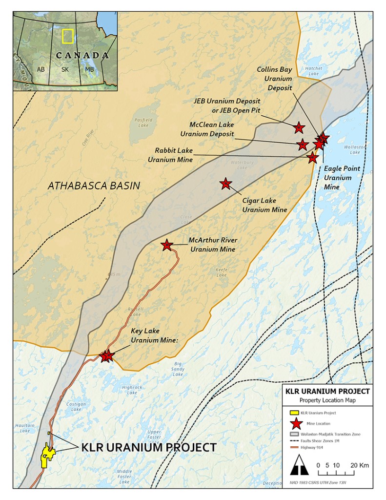
The KLR Uranium Project covers approximately 5,521 hectares along the Key Lake Road, ~90 km south of Cameco's Key Lake Mine and mill, where over 209 million pounds of uranium were produced between 1983 and 2002.¹
The property lies almost entirely within the Wollaston Mudjatik Transition Zone (WMTZ) — the prolific structural corridor that also hosts the Key Lake, Cigar Lake, and McArthur River uranium deposits. Access to the project is excellent via provincial highway 914, which bisects the property.
Historical exploration work includes heliborne VTEM surveys, ground magnetic and IP surveys, prospecting, and localized drilling programs that have outlined multiple priority drill targets. The current exploration model, inspired by NexGen's Arrow deposit, indicates potential for a higher-grade feeder anomaly at depth beneath the radioactive halos identified to date.
The KLR Project benefits from exceptional road access and proximity to established regional mining infrastructure along Saskatchewan's Key Lake Road corridor.
Provincial Highway 914 bisects the property, providing direct, all-season road access and significantly reducing logistical costs for exploration programs.
Located approximately 90 km south of Cameco's Key Lake Mine and mill complex — one of the world's largest uranium processing facilities.
Proximity to established roads, power corridors, and regional mining infrastructure supports efficient and lower-cost exploration operations.
The KLR Project lies almost entirely within the Wollaston Mudjatik Transition Zone (WMTZ), the prolific structural corridor that controls uranium mineralization at the Key Lake, Cigar Lake, and McArthur River uranium deposits — three of the world's most significant uranium mines.
The property's geology features a north-south trending fault system, consistent with the WMTZ structural controls. The DD Zone is characterized by this fault orientation, and previous prospecting and drilling have consistently identified highly anomalous uranium mineralization along it.
The current exploration model — inspired by NexGen's Arrow deposit — indicates potential for a higher-grade feeder anomaly at depth beneath the radioactive halos identified to date, with uranium enrichment in drilling increasing with depth.
Click any map to view full size.
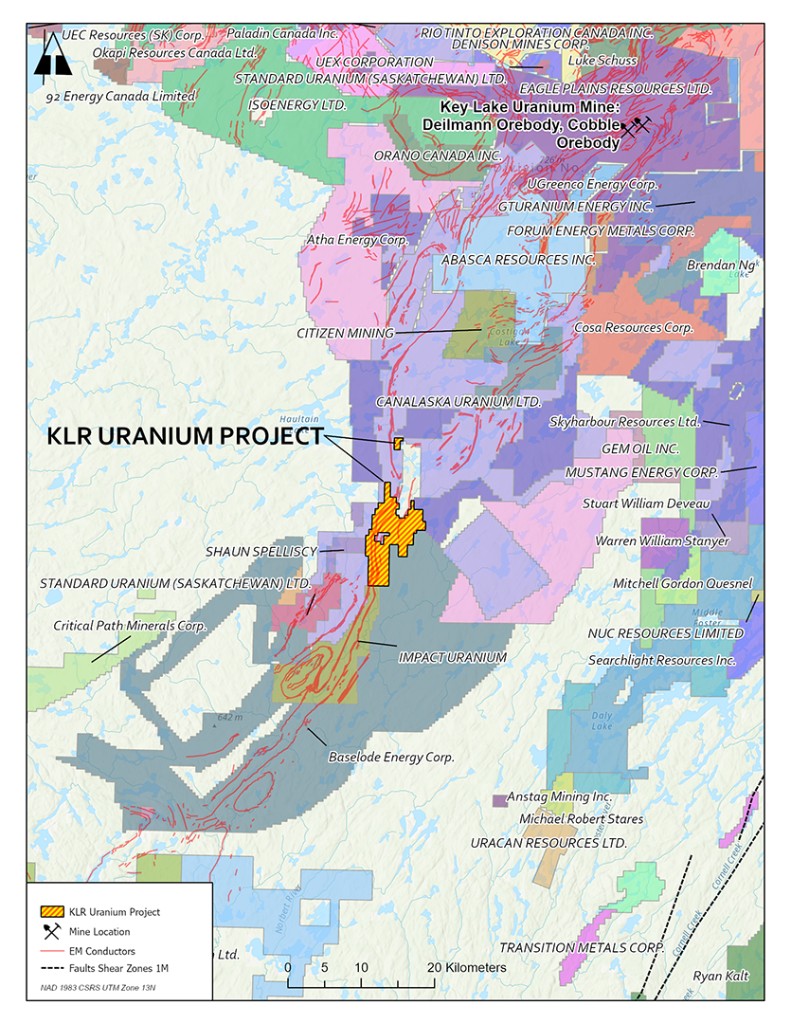
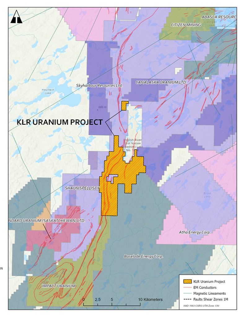
Historical and recent exploration has defined two key target zones on the KLR Project, both showing compelling uranium mineralization.
Characterized by a north-south trending fault consistent with the WMTZ. Uranium enrichment increasing with depth.
The DD Zone, first identified by Forum Uranium, has been the focus of multiple historical drilling campaigns and the 2023 Kirkstone Metals drill program. Six shallow holes drilled in 2023 intersected anomalous uranium enrichment increasing with depth.³
Located along Highway 914. Near-surface high-grade interval identified in 2015 ground geophysics and man-portable drilling.
Ground geophysics and man-portable drilling in 2015 identified a near-surface interval of high-grade uranium mineralization, suggesting the presence of a significant uranium system in the Highway Zone.²
Multiple drilling campaigns at the DD Zone have consistently identified highly anomalous uranium mineralization with values increasing at depth.
The company has devised a multiphase exploration strategy to leverage the wealth of historic exploration data on this project and advance toward high-grade discovery.
The first phase calls for an IP survey in the northern extent of the project area, focused on the DD Zone — precisely where 2023 drilling encountered uranium enrichment increasing with depth.
IP survey data will be used to define high-priority diamond drilling targets in subsequent programs, focused on testing the interpreted high-grade feeder anomaly at depth.
Qualified Person: Tim Henneberry, Professional Geoscientist, is the designated Qualified Person as defined by National Instrument 43-101. He is responsible for, and has reviewed and approved, the scientific and technical information contained on this page.
¹ Fall 2007 and Winter 2008 Drilling Report Key Lake Road Project, June 2008, B. Tan and K. Wheatley for Forum Uranium Corporation. · ² Technical Report on the Key Lake Road Property, November 21, 2016, E. Harrington for Broome Capital Corp. · ³ 2023 KLR Drill Program Summary, Feb 8 to Mar 20, 2025.